Reply With Quote


http://www.cartographersguild.com/sh...ad.php?t=29412 may offer some help. There are lots of items on that page; check out the ones at the bottom of the page, especially.


Hi all. I'm trying to create a more in-depth heightmap than what I have for a big conworld project I'm doing with friends. We have a world map we've been using for a long time with terrains marked on it, but it doesn't go in depth as much as we'd like. Here's the current map:
Attachment 83035
I can turn that into a grayscale heightmap very easily, but when I do, the expected behaviour is that it will create flat areas at each contour instead of sloping up. However, I want to generate slopes between the contour lines as well. Is there any good way to do this in Photoshop or Wilbur? In addition, is there a way to feed already existing rivers into the erosion filter or something? Thank you!!
Here's the full map, by the way. We put a lot of effort into this.
Thank you~
http://www.cartographersguild.com/sh...ad.php?t=29412 may offer some help. There are lots of items on that page; check out the ones at the bottom of the page, especially.
I managed to figure out that the deterrace tool existed, and a combination of that and the Gaussian Blur tool is working wonders for me! I'll let you know if I have any more problems (and I'll be sure to post a final link here~)
easily ? that is the question
I think you will find that about 90% of your starts will end up in the trash.
At least for the early part of the learning curve .
the developer "waldronate" starts with a black ( 0 ) and white ( 255) only image
me i start with something more detailed and use wilbur to erode the surface
-- different ways of doing things --
--- 90 seconds to Midnight ---
--------
--- Penguin power!!! ---
I tend to use three or more masks and a multi resolution technique these days. Predefined rivers may make up other masks. Better inputs can give better outputs. I keep trying to find a minimum level of input and time to get plausible results.
The main difficulty for me was the contours; the deterrace tool solved that problem. I'm having to use masks for rivers + lakes, but it's all good! Thanks for your help!
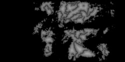
i use a distance transform on the water ( ocean and river ) mask , then move the gama point and get something like this
i mix that with the mountains ( extracted from your image in the first post)
this gives me river valleys
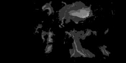
and i end up with this ( 8 bit copy of the float and only 2048x1024 )
this is a quick low iteration low resolution
Last edited by johnvanvliet; 04-28-2016 at 06:49 PM.
--- 90 seconds to Midnight ---
--------
--- Penguin power!!! ---
 Posting Permissions