Some pentagonal inspiration (I particularly like the second as a city shape...):Originally Posted by Arthur

-Rob A>

Some pentagonal inspiration (I particularly like the second as a city shape...):
-Rob A>
My tutorials: Using GIMP to Create an Artistic Regional Map ~ All My Tutorials
My GIMP Scripts: Rotating Brush ~ Gradient from Image ~ Mosaic Tile Helper ~ Random Density Map ~ Subterranean Map Prettier ~ Tapered Stroke Path ~ Random Rotate Floating Layer ~ Batch Image to Pattern ~ Better Seamless Tiles ~ Tile Shuffle ~ Scale Pattern ~ Grid of Guides ~ Fractalize path ~ Label Points
My Maps: Finished Maps ~ Challenge Entries ~ My Portfolio: www.cartocopia.com
Actually, I kind of like the first one more from an idea stand point. The repeating pattern (though not necessarily that one) strikes me as a cool idea. So a city divided by a large geometric shape and each section sub divided into a geometric shape, and each buidling the same geometric shape within....
Joe
My Finished Maps
Works in Progress(or abandoned tests)
My Tutorials:
Explanation of Layer Masks in GIMP
How to create ISO Mountains in GIMP/PS using the Smudge tool
----------------------------------------------------------
Unless otherwise stated by me in the post, all work is licensed under a Creative Commons Attribution-Noncommercial 3.0 United States License.
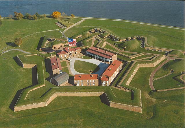
Well five pointed stars are traditional in late military defence:
Definitely possible to base a city around a core such as that.


Thanks, that's all interesting. I'll try to use the repeating pattern idea, and the central Manse will probably have that pentagonal shape.
I've found a technical difficulty, though. The tutorial I was following so far was Pyradon's tutorial for building city maps. The map he uses as example, though, is for a "natural" city, which doesn't quite match the profile of Denandsor.
What I have so far is attached. Explaining: every piece of open terrain outside the walls will be covered with trees. The city is right in the middle of a jungle. I don't know if I mentioned before, but nothing lives in the city at the time this map was made, though there are animated creatures that have been keeping the city clean and protected in the last eight centuries. The Outer purple decagon is where the walls will be. The inner light blue decagon and the other light blue lines are the main roads. They are about [Distance between the walls and the center]/1,618 units away from the center, so I guess that also helped to gave a "perfect" idea to the architecture. Also, the central manse is pretty much huge.
My idea from this point is to define the lesser streets, maybe organizing the blocks in varied geometrical shapes, place the other places of interest (there are a few I'd like to insert...), and, once everything is placed where it should be, start beautifying it with textures, colors and such. I'm not sure how I'll do that yet, but I intend to make most of the city in a bright blue color, trying to give it a "glowing" idea.
Thank you all again, the Cartographer's Guild has been helping me a lot.
P.S.: the original image is 3500x3500
Last edited by Arthur; 06-28-2008 at 05:43 AM.
Another change of ways. Instead of making a nearly realistic map, I now intend to make something more like a schematic representation. For a city like Denandsor, doing otherwise would be too time consuming and the result wouldn't be great. I'm taking a lot of inspiration from this map:
I have inserted a few textures, though, and it is know looking like the attached image.

Thats a real neat map. You obviously have a great deal of experience with your art packages.
 Posting Permissions

 Reply With Quote