


Difference clouds is really just a shortcut for creating a new layer, rendering clouds, setting the blend mode to difference, then merging down.
-Rob A>

Difference clouds is really just a shortcut for creating a new layer, rendering clouds, setting the blend mode to difference, then merging down.
-Rob A>
My tutorials: Using GIMP to Create an Artistic Regional Map ~ All My Tutorials
My GIMP Scripts: Rotating Brush ~ Gradient from Image ~ Mosaic Tile Helper ~ Random Density Map ~ Subterranean Map Prettier ~ Tapered Stroke Path ~ Random Rotate Floating Layer ~ Batch Image to Pattern ~ Better Seamless Tiles ~ Tile Shuffle ~ Scale Pattern ~ Grid of Guides ~ Fractalize path ~ Label Points
My Maps: Finished Maps ~ Challenge Entries ~ My Portfolio: www.cartocopia.com


thanks its all in the power of the alpha channels
not sure which way to go with this map
any suggestions
I would like to increase the line weight of the coast line and distress it
and i am not sure how to address forests
any help or suggestions you can give me would be greatly appreciated
Last edited by RobA; 05-03-2008 at 02:37 PM. Reason: fixed inline image
This is coming along wonderfully!! Keep going, keep going.
Don
My gallery is here
__________________________________________________ _______
"Keep your mind in hell, but despair not." --Saint Silouan [1866-1938]
I'd stick with the hand drawn mountains.
-Rob A>
My GIMP Scripts: Rotating Brush ~ Gradient from Image ~ Mosaic Tile Helper ~ Random Density Map ~ Subterranean Map Prettier ~ Tapered Stroke Path ~ Random Rotate Floating Layer ~ Batch Image to Pattern ~ Better Seamless Tiles ~ Tile Shuffle ~ Scale Pattern ~ Grid of Guides ~ Fractalize path ~ Label Points
My Maps: Finished Maps ~ Challenge Entries ~ My Portfolio: www.cartocopia.com


Seconds YodA's vote for hand drawn mountains. definitely the way to go
I'm not picking on the map in question, but just commenting in general.hand drawn mountains. definitely the way to go
If by "hand-drawn mountains" you mean those orthographic or semi-sideview peaks, which occur in a bazillion maps I've seen (I bring to mind the original maps in Tolkien's Middle Earth works), it's interesting to note that such features are usually the single exception to an otherwise totally birdseye-view or satellite-view map.
I was reading an awesome book about cartographic history at a friend's house ... I don't remember the name, but I can email her ... and it mentioned the development these orthographic mountain styles specifically.
Other elements are sometimes orthographic. Walled towns are sometimes shown from a side view, with gates visible in the walls, and towers rising from behind the walls -- in birdseye a wall is a line and you can't see a gate. Forests are sometimes shown as lots of trees with vertical trunks visible below their canopies.
I wonder if a mapper ought to consider whether to use all-orthographic, all-birdseye, or a mix, for each project. And if it's a mix, how do you choose which element gets which style?
Venus Public Transit, Map Of Ceres, Jack Vance's Ports Of Call & Lurulu ... why do I only have 3 maps here?
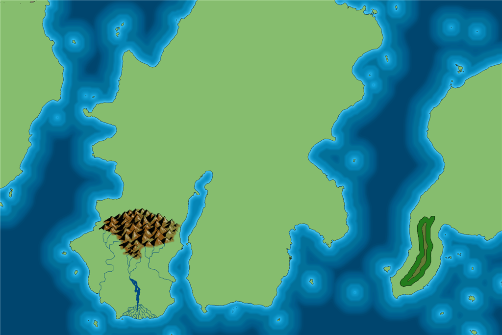
speaking of Tolkienesk mountains
more progress on the Map
am i moving in the right direction?
wow this is time consuming
 Posting Permissions

 Reply With Quote